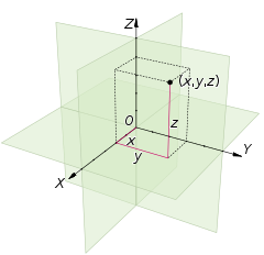
Earth, more precision, have more density on its equator. Which means, the distance to the earth's core from equator is greatest than other surface of earth. For some reason, we assumed that earth as a sphere that every P on surface have an equal distance to the core. On three dimensional space, we used Cartesian coordinate for 3D object as below.
Three dimensional Cartesian coordinate placed a point A relatively to the O, the initial point of the coordinate system. Picture placed a point called (x,y,z) on that coordinate. But on earth, we will challenge a difficulties to find the value of x, y, and z as pictures. So, we used other coordinate system that more easily to use.
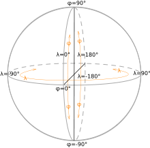
First we assume the radius of earth is equal in each P on surface that equal to R. Second, we measure an height angle from equator that called latitude (phi). Positive if its above the equator, and negative for the opposite. The Third, we measure the distance angle from the meridian line that through Greenwich in England that called longitude (lamda). So we could graph earth as below.
On a polar coordinate system, a point A on surface of earth is (r, phi, lamda). This coordinate can be transformed to Cartesian models as {r cos (phi) cos (lamda), r sin (lamda) cos (phi), r sin (phi)}.


No comments:
Post a Comment